版本:vue@3.0.5 + echarts@5.1.2
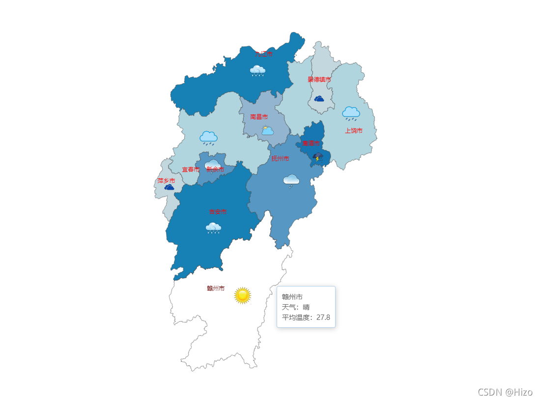
本文将介绍如何使用 echarts 绘制一个省级地图(以江西省为例)
一、安装 echarts
npm i echarts --save-dev
二、引入
import * as echarts from "echarts";
import jiangxi from '../assets/jiangxi.json';
三、初始化
< 1 > 创建一个图表容器
<div id="main" style="width: 700px; height: 700px; margin: 80px auto"></div>
< 2 > 初始化图表
const myChart = echarts.init(document.getElementById("main"));
四、配置数据
< 1 > 制造一些假数据(这里也可以通过接口获取数据然后去处理对应的格式)
const cityInfo = [
    {
        name: "新余市",
        x: 240,
        y: 260,
        weather: "小雨",
        images: "src/assets/weather/small.png",
        itemStyle: { areaColor: "#5698c3" },
        temp: "26.8",
    },
    {
        name: "赣州市",
        x: 300,
        y: 520,
        weather: "晴",
        images: "src/assets/weather/晴.png",
        itemStyle: { areaColor: "#d9a40e" },
        temp: "27.8",
    },
    {
        name: "吉安市",
        x: 240,
        y: 380,
        weather: "大雨",
        images: "src/assets/weather/大雨.png",
        itemStyle: { areaColor: "#1781B5" },
        temp: "28.8",
    },
    {
        name: "抚州市",
        x: 400,
        y: 290,
        weather: "小雨",
        images: "src/assets/weather/small.png",
        itemStyle: { areaColor: "#5698c3" },
        temp: "25.8",
    },
    {
        name: "鹰潭市",
        x: 455,
        y: 240,
        weather: "雷阵雨",
        images: "src/assets/weather/雷阵雨.png",
        itemStyle: { areaColor: "#1677B3" },
        temp: "24.8",
    },
    {
        name: "上饶市",
        x: 520,
        y: 150,
        weather: "中雨",
        images: "src/assets/weather/中雨.png",
        itemStyle: { areaColor: "#B0D5DF" },
        temp: "30.8",
    },
    {
        name: "景德镇市",
        x: 455,
        y: 120,
        weather: "阴",
        images: "src/assets/weather/阴.png",
        itemStyle: { areaColor: "#C3D7DF" },
        temp: "24.8",
    },
    {
        name: "南昌市",
        x: 350,
        y: 180,
        weather: "多云",
        images: "src/assets/weather/多云.png",
        itemStyle: { areaColor: "#93B5CF" },
        temp: "21.8",
    },
    {
        name: "宜春市",
        x: 230,
        y: 200,
        weather: "中雨",
        images: "src/assets/weather/中雨.png",
        itemStyle: { areaColor: "#B0D5DF" },
        temp: "27.8",
    },
    {
        name: "萍乡市",
        x: 150,
        y: 300,
        weather: "阴",
        images: "src/assets/weather/阴.png",
        itemStyle: { areaColor: "#C3D7DF" },
        temp: "26.8",
    },
    {
        name: "九江市",
        x: 330,
        y: 60,
        weather: "大雨",
        images: "src/assets/weather/大雨.png",
        itemStyle: { areaColor: "#1781B5" },
        temp: "28.8",
    },
];
< 2 > 配置 option
参考配置:https://www.runoob.com/echarts/echarts-setup.html
const option = {
	// 容器背景颜色
    backgroundColor: 'transparent',
    // 鼠标移入显示浮层
    tooltip: {
        trigger: 'item',
        formatter: function (params) {
            const dataIndex = params.dataIndex;

            const cityName = params.name + '<br />';
            const weatherTip = '天气:' + cityInfo[dataIndex].weather + '<br />';
            const tempTip = '平均温度:' + cityInfo[dataIndex].temp;

            return cityName + weatherTip + tempTip;
        }
    },

    series: [
        {
            type: 'map',
            map: '江西',
            roam: false,
            top: '11%',
            aspectScale: 0.75, //长宽比
            zoom: 1.2, //缩放比
            x: '25%',
            selectedMode: 'single',
            label: {
                show: true,
                color: "red"
            },
            itemStyle: {
                areaStyle: {
                    color: '#B1D0EC'
                },
                color: '#B1D0EC',
            },
            //鼠标hover样式,
            emphasis: {
                itemStyle: {
                    areaColor: 'transparent'
                }
            },
            data: cityInfo
        },
        {
            // 配置显示方式为用户自定义
            type: 'custom',
            coordinateSystem: 'geo',
            // 具体实现自定义图标的方法
            renderItem: function (params, api) {
                return {
                    type: 'image',
                    style: {
                        image: cityInfo[params.dataIndex].images,
                        x: cityInfo[params.dataIndex].x,
                        y: cityInfo[params.dataIndex].y
                    }
                }
            },
            data: cityInfo
        }
    ]
};
五、绘制图表
echarts.registerMap('江西', jiangxi);
myChart.setOption(option);
六、效果图

友情提示:省级地图数据 和 天气图标 需要自行下载并且配置路径
地图:http://datav.aliyun.com/tools/atlas/index.html
图标:https://www.iconfont.cn/