需求: 构建点位要素服务图层FeatureLayer
分析:由于没有发布要素服务图层,故需自定义方式构建
new FeatureLayer(featureCollectionObject, options?)
1.选择构建FeatureLayer的方法及思路
1.选择构建的方式new FeatureLayer(featureCollectionObject, options?)
 ?2.查看 (featureCollectionObject, options? )对应的值

?
2.版本一实现代码:
<!DOCTYPE html>
<html>

<head>
    <meta http-equiv="Content-Type" content="text/html; charset=utf-8" />
    <title>Test Map</title>
    <link rel="stylesheet" href="https://js.arcgis.com/3.24/esri/css/esri.css">
    <script src="https://js.arcgis.com/3.24/"></script>
    <script src="https://code.jquery.com/jquery-3.3.1.min.js"></script>
    <style>
        html,
        body,
        #map {
            height: 100%;
            width: 100%;
            margin: 0;
            padding: 0;
        }

        #addbtn {
            position: absolute;
            z-index: 999;
            top: 20px;
            left: 100px;
        }
    </style>
    <script>


        require([
            "esri/map",
            "esri/SpatialReference",
            "esri/layers/FeatureLayer",
            "esri/geometry/Point",
            "esri/tasks/FeatureSet",
            "esri/graphic",
            "dojo/domReady!",
            "esri/symbols/SimpleMarkerSymbol",
            "esri/Color",
        ],
            function (Map, SpatialReference, FeatureLayer, Point, FeatureSet, Graphic,Color,SimpleMarkerSymbol) {
                var map = new Map("map", {
                    basemap: "osm",
                    center: [116.943089, 36.643737],
                    zoom: 18
                });

                var spatialReference = new SpatialReference(4326);
                var pointArr = [
                    new Point(116.94431351934418, 36.642791191513744, spatialReference),
                    new Point(116.94313181636085, 36.644263733181496, spatialReference),
                    new Point(116.94323946773243, 36.644333923319806, spatialReference),
                    new Point(116.94214699103674, 36.64316768441554, spatialReference),
                    new Point(116.94173145496477, 36.643359669286696, spatialReference),
                    new Point(116.94251530866333, 36.644235392555245, spatialReference),
                ];

                var features = [];
                let pointSymbol =  new SimpleMarkerSymbol({
                    "color": [255,255,255,64],
                    "size": 12,
                    "angle": -30, // 标记物相对于屏幕的角度,单位为角度。
                    "xoffset": 0,
                    "yoffset": 0,
                    "type": "esriSMS",
                    "style": "esriSMSCircle", // 圆
                    "outline": { //标记符号的轮廓。
                        "color": '#ff0000',
                        "width": 10,
                        "type": "esriSLS",
                        "style": "esriSLSSolid" // 实线
                    }
                    });
                for (var i = 0; i < pointArr.length; i++) {
                    var graphics = new Graphic(pointArr[i], pointSymbol, { "OBJECTID": i, "LON": pointArr[i].x, "LAT": pointArr[i].y });
                    features.push(graphics);
                }

                var fields = [
                    { name: "OBJECTID", type: "esriFieldTypeOID", alias: "OBJECTID" },
                    { name: "LON", type: "esriFieldTypeDouble", alias: "LON" },
                    { name: "LAT", type: "esriFieldTypeDouble", alias: "LAT" }
                ];

                var featureSetJson = {
                    displayFieldName: "",
                    geometryType: "esriGeometryPoint",
                    fieldAliases: {
                        OBJECTID: "OBJECTID",
                        LON: "LON",
                        LAT: "LAT"
                    },
                    fields: fields,
                    spatialReference: spatialReference,
                    features: features
                };
                var featuresSet = new FeatureSet(featureSetJson);

                var layerDefinition = {
                    "geometryType": "esriGeometryPoint",
                    "fields": fields
                };
                var featureCollection = {
                    layerDefinition: layerDefinition,
                    featureSet: featuresSet
                };
                // 地图加载完成后执行函数
                map.on('load', () => {
                    var featureLayer = new FeatureLayer(featureCollection);
                map.addLayer(featureLayer);
                })
            })

    </script>
</head>

<body>
    <div id="map">
        <button id="addbtn">PictureGeometry</button>
    </div>
</body>

</html>
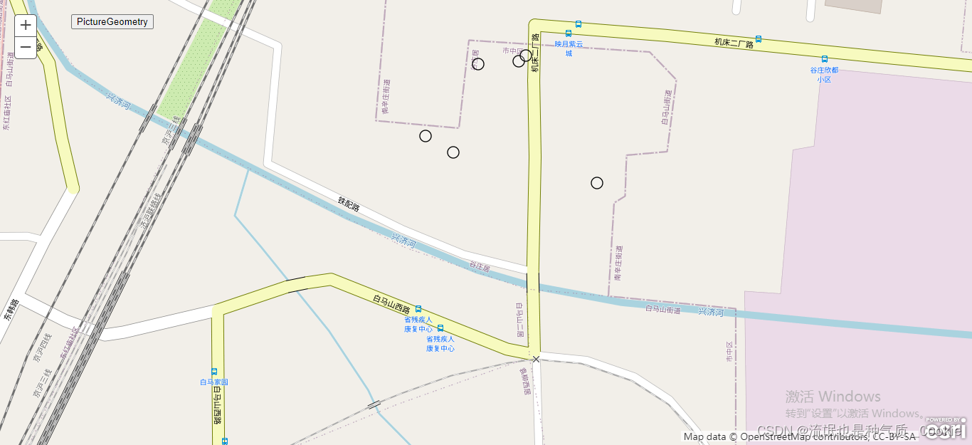
?版本一效果图:

3.版本二实现代码 思路更清晰:
<!DOCTYPE html>
<html>
<head>
    <meta http-equiv="Content-Type" content="text/html; charset=utf-8" />
    <title>Test Map</title>
    <link rel="stylesheet" href="https://js.arcgis.com/3.24/esri/css/esri.css">
    <script src="https://js.arcgis.com/3.24/"></script>
    <script src="https://code.jquery.com/jquery-3.3.1.min.js"></script>
    <style>
        html,
        body,
        #map {
            height: 100%;
            width: 100%;
            margin: 0;
            padding: 0;
        }

        #addbtn {
            position: absolute;
            z-index: 999;
            top: 20px;
            left: 100px;
        }
    </style>
    <script>
        require([
            "esri/map",
            "esri/SpatialReference",
            "esri/graphic",
            "esri/geometry/Point",
            "esri/symbols/PictureMarkerSymbol",
            "esri/symbols/SimpleMarkerSymbol",
            "esri/geometry/Polygon",
            "esri/symbols/PictureFillSymbol",
            "esri/symbols/SimpleFillSymbol",
            "esri/symbols/SimpleLineSymbol",
            "esri/Color",
            "dojo/domReady!",
            "esri/layers/FeatureLayer",
            "esri/SpatialReference",
        ], function (Map,SpatialReference, Graphic, Point,PictureMarkerSymbol,SimpleMarkerSymbol,
            Polygon, PictureFillSymbol, SimpleFillSymbol,FeatureLayer,SpatialReference,
            SimpleLineSymbol,Color,) {
            var map = new Map("map", {
                // 底图格式
                basemap: "osm",
                // 视觉中心点
                center: [106.897222, 39.858333],
                // 缩放等级
                zoom: 17,

            });
            // 地图加载完成后执行函数
            map.on('load',()=>{
                addFeatureLayer_Point()
            })

            function addGeometry() {
                // "wkid": 4326  102100的不同 位置也会不同
                var geometry = new Point({ "x": 13216981.21329723, "y": 3772852.221308317, "spatialReference": { "wkid": 102100 } });
                var symbol = new PictureMarkerSymbol("1.png",40,40);
                // 前面二行可以参考官方 这句整合需要经验(你看到了类似的例子/或者记住这样的写法)
                map.graphics.add(new Graphic(geometry, symbol));
            }
        function addFeatureLayer_Point() {// 添加点要素图层
            var layerDefinition = {//图层信息
            "geometryType": "esriGeometryPoint",//几何类型,此处为点
            "objectIdField": "ObjectID",//要素id字段  一定是和点位的字段一一对应
            "drawingInfo": {//显示信息
                "renderer": {//渲染
                    "type": "simple",//渲染类型
                    "symbol": {//符号
                        "color": [0, 48, 161, 255],//符号颜色
                        "size": 120,//符号大小
                        "type": "esriSMS",//符号类型
                        "style": "esriSMSCircle"//符号样式
                    }
                }
            },
            "fields": [//字段
                {
                    "name": "ObjectID",//名称   一定是和点位的字段一一对应
                    "alias": "ObjectID",//别名 一定是和点位的字段一一对应
                    "type": "esriFieldTypeOID"//类型 一定是和点位的字段一一对应
                },
                {
                    "name": "val",//名称
                    "alias": "val",//别名
                    "type": "esriFieldTypeDouble"//类型
                }, {
                    "name": "pscode",//名称
                    "alias": "pscode",//别名
                    "type": "esriFieldTypeString"//类型
                }, {
                    "name": "pollutantcode",//名称
                    "alias": "pollutantcode",//别名
                    "type": "esriFieldTypeString"//类型
                }
                ]
        };
        var spatialReference = new SpatialReference(4326);
        var featuresJson = [//要素json
            {
                "attributes": {//属性信息
                    "val": 5041,
                    "pscode": "150300000020",
                    "ObjectID": 0,
                    "pollutantcode": "A21026"
                },
                "geometry": {//几何信息
                    "y": 39.858333,//要素的y坐标
                    "spatialReference": {
                        "wkid": spatialReference
                    },//要素空间参照坐标系的wkid
                    "x": 106.897222//要素的x坐标
                }
            },
            {
                "attributes": {
                    "val": 54471,
                    "pscode": "150600000082",
                    "ObjectID": 1,
                    "pollutantcode": "A21026"
                },
                "geometry": {
                    "y": 39.607433,
                    "spatialReference": {
                        "wkid": 4326
                    },
                    "x": 109.831328
                }
            },
            {
                "attributes": {
                    "val": 3399,
                    "pscode": "150300000016",
                    "ObjectID": 2,
                    "pollutantcode": "A21026"
                },
                "geometry": {
                    "y": 39.466667,
                    "spatialReference": {
                        "wkid": 4326
                    },
                    "x": 106.700556
                }
            },
            {
                "attributes": {
                    "val": 41,
                    "pscode": "150300000021",
                    "ObjectID": 3,
                    "pollutantcode": "A21026"
                },
                "geometry": {
                    "y": 39.8325,
                    "spatialReference": {
                        "wkid": 4326
                    },
                    "x": 106.851667
                }
            },
            {
                "attributes": {
                    "val": 144497,
                    "pscode": "150600000005",
                    "ObjectID": 4,
                    "pollutantcode": "A21026"
                },
                "geometry": {
                    "y": 40.066667,
                    "spatialReference": {
                        "wkid": 4326
                    },
                    "x": 110.266667
                }
            },
            {
                "attributes": {
                    "val": 288,
                    "pscode": "150600000046",
                    "ObjectID": 5,
                    "pollutantcode": "A21026"
                },
                "geometry": {
                    "y": 40.048611,
                    "spatialReference": {
                        "wkid": 4326
                    },
                    "x": 111.2425
                }
            },
            {
                "attributes": {
                    "val": 169,
                    "pscode": "150600000119",
                    "ObjectID": 6,
                    "pollutantcode": "A21026"
                },
                "geometry": {
                    "y": 42.500833,
                    "spatialReference": {
                        "wkid": 4326
                    },
                    "x": 109.835556
                }
            }
            ];
        var featureCollection = {//图层信息
            "layerDefinition": layerDefinition,//图层定义
            "featureSet": {//要素集
                "features": featuresJson,//要素
                "geometryType": "esriGeometryPoint"//几何类型,此处为点
            }
        };
        let featureLayer = new FeatureLayer(featureCollection, {
            id: "featureLayer_point",
            })
        map.addLayer(featureLayer);
    }

        });
    </script>
</head>
<body>
    <div id="map">

</body>
</html>