文章目录
1、简介
1.1 Web墨卡托投影
墨卡托投影,是正轴等角圆柱投影,又称等角圆柱投影,圆柱投影的一种,由荷兰地图学家墨卡托(G. Mercator)于1569年创拟。为地图投影方法中影响最大的。
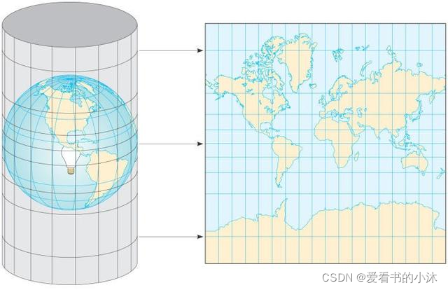
用一张纸卷成圆柱,围住地球仪;然后在地球仪的球心放一个发光的灯泡,地球仪上的地图会在圆柱纸上形成投影;把这张纸平展开,就是我们常见平面世界地图。上面所讲的投影法叫墨卡托投影(Mercator Projection)。
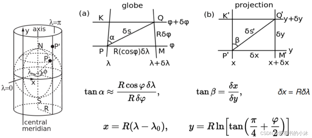
地图学是一门严谨的科学,需要数学模型和精确的公式计算,再做近似处理,墨卡托投影数学模型如下:

当然,地形面积按墨卡托投影投射到平面后是有一定变形的,纬度越高,也就是越靠近两极变形越大。
Web墨卡托投影(又称球体墨卡托投影)是墨卡托投影的变种,它接收的输入是Datum为WGS84的经纬度,但在投影时不再把地球当做椭球而当做半径为6378137米的标准球体,以简化计算。
Web墨卡托投影有两个相关的投影标准,经常搞混:
- EPSG4326:Web墨卡托投影后的平面地图,但仍然使用WGS84的经度、纬度表示坐标;
- EPSG3857:Web墨卡托投影后的平面地图,坐标单位为米。
X and Y:
- X goes from 0 (left edge is 180 °W) to 2zoom ? 1 (right edge is 180 °E)
- Y goes from 0 (top edge is 85.0511 °N) to 2zoom ? 1 (bottom edge is 85.0511 °S) in a Mercator projection
1.2 经纬度坐标系
国内主要采用如下三种:
-
WGS84:为一种大地坐标系,也是目前广泛使用的GPS全球卫星定位系统使用的坐标系。
-
GCJ02:又称火星坐标系,是由中国国家测绘局制订的地理信息系统的坐标系统。由WGS84坐标系经加密后的坐标系。
-
BD09:为百度坐标系,在GCJ02坐标系基础上再次加密。其中bd09ll表示百度经纬度坐标,bd09mc表示百度墨卡托米制坐标。
使用OpenStreetMap的坐标为WGS84;使用高德地图、腾讯地图的坐标为GCJ02;使用百度地图的坐标为BD09;谷歌地图和Bing地图的中国部分采用了高德地图的数据,所以坐标为GCJ02。
WGS84的坐标转化为GCJ02的坐标是单向的,即WGS84的坐标能够准确地变换为GCJ02坐标;但GCJ02坐标转换为WGS84时会存在精度损失。
1.3 瓦片定义
瓦片:指将一定范围内的地图按照一定的尺寸和格式,按缩放级别或者比例尺,切成若干行和列的正方形栅格图片,对切片后的正方形栅格图片被形象的称为瓦片(Tile)。
对于经过墨卡托投影为平面的世界地图,在不同的地图分辨率(整个世界地图的像素大小)下,通过切割的方式将世界地图划分为像素为 256 × 256的地图单元,划分成的每一块地图单元称为地图瓦片。
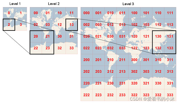
经过Web墨卡托投影后,地图就变为平面的一张地图。为此,我们对这张地图进行等级切分。在最高级(zoom=0),需要的信息最少,只需保留最重要的宏观信息,因此用一张256x256像素的图片表示即可;在下一级(zoom=1),信息量变多,用一张512x512像素的图片表示;以此类推,级别越低的像素越高,下一级的像素是当前级的4倍。这样从最高层级往下到最低层级就形成了一个金字塔坐标体系。
1.4 瓦片编号
- 谷歌XYZ:Z表示缩放层级,Z=zoom;XY的原点在左上角,X从左向右,Y从上向下。
- TMS:开源产品的标准,Z的定义与谷歌相同;XY的原点在左下角,X从左向右,Y从下向上。
- QuadTree:微软Bing地图使用的编码规范,Z的定义与谷歌相同,同一层级的瓦片不用XY两个维度表示,而只用一个整数表示,该整数服从四叉树编码规则
- 百度XYZ:Z从1开始,在最高级就把地图分为四块瓦片;XY的原点在经度为0纬度位0的位置,X从左向右,Y从下向上。
1.5 瓦片和像素
| Level of Detail | Map Width and Height (pixels) | Ground Resolution (meters / pixel) | Map Scale(at 96 dpi) |
|---|---|---|---|
| 1 | 512 | 78,271.5170 | 1 : 295,829,355.45 |
| 2 | 1,024 | 39,135.7585 | 1 : 147,914,677.73 |
| 3 | 2,048 | 19,567.8792 | 1 : 73,957,338.86 |
| 4 | 4,096 | 9,783.9396 | 1 : 36,978,669.43 |
| 5 | 8,192 | 4,891.9698 | 1 : 18,489,334.72 |
| 6 | 16,384 | 2,445.9849 | 1 : 9,244,667.36 |
| 7 | 32,768 | 1,222.9925 | 1 : 4,622,333.68 |
| 8 | 65,536 | 611.4962 | 1 : 2,311,166.84 |
| 9 | 131,072 | 305.7481 | 1 : 1,155,583.42 |
| 10 | 262,144 | 152.8741 | 1 : 577,791.71 |
| 11 | 524,288 | 76.4370 | 1 : 288,895.85 |
| 12 | 1,048,576 | 38.2185 | 1 : 144,447.93 |
| 13 | 2,097,152 | 19.1093 | 1 : 72,223.96 |
| 14 | 4,194,304 | 9.5546 | 1 : 36,111.98 |
| 15 | 8,388,608 | 4.7773 | 1 : 18,055.99 |
| 16 | 16,777,216 | 2.3887 | 1 : 9,028.00 |
| 17 | 33,554,432 | 1.1943 | 1 : 4,514.00 |
| 18 | 67,108,864 | 0.5972 | 1 : 2,257.00 |
| 19 | 134,217,728 | 0.2986 | 1 : 1,128.50 |
| 20 | 268,435,456 | 0.1493 | 1 : 564.25 |
| 21 | 536,870,912 | 0.0746 | 1 : 282.12 |
| 22 | 1,073,741,824 | 0.0373 | 1 : 141.06 |
| 23 | 2,147,483,648 | 0.0187 | 1 : 70.53 |
- Zoom levels
| zoom level | tile coverage | number of tiles | tile size(*) in degrees |
|---|---|---|---|
| 0 | 1 tile | covers whole world | 1 tile 360° x 170.1022° |
| 1 | 2 × 2 tiles | 4 tiles | 180° x 85.0511° |
| 2 | 4 × 4 tiles | 16 tiles | 90° x [variable] |
| n | 2n × 2n tiles | 22n tiles | 360/2n° x [variable] |
| 12 | 4096 x 4096 tiles | 16 777 216 | 0.0879° x [variable] |
| 16 | 232 ≈ 4 295 million tiles | ||
| 17 | 17.2 billion tiles | ||
| 18 | 68.7 billion tiles | ||
| 19 | Maximum zoom for Mapnik layer | 274.9 billion tiles |
1.6 瓦片计算公式
https://wiki.openstreetmap.org/wiki/Slippy_map_tilenames


- Lon./lat. to tile numbers:
import math
def deg2num(lat_deg, lon_deg, zoom):
  lat_rad = math.radians(lat_deg)
  n = 2.0 ** zoom
  xtile = int((lon_deg + 180.0) / 360.0 * n)
  ytile = int((1.0 - math.asinh(math.tan(lat_rad)) / math.pi) / 2.0 * n)
  return (xtile, ytile)
- Tile numbers to lon./lat:
import math
def num2deg(xtile, ytile, zoom):
  n = 2.0 ** zoom
  lon_deg = xtile / n * 360.0 - 180.0
  lat_rad = math.atan(math.sinh(math.pi * (1 - 2 * ytile / n)))
  lat_deg = math.degrees(lat_rad)
  return (lat_deg, lon_deg)
我们这里开始测试一下上面的公式和代码,选择北京大学的未名湖为目标,测试如下:
- (1)查询经纬度
地球在线,https://map.jiqrxx.com/jingweidu/
地球在线2,https://www.earthol.com/g/

- (2)记录目标的经纬度

未名湖的经纬度(纬度,经度):39.99476256945049, 116.30985796451569
-(3)计算瓦片坐标编号
计算结果为:215766, 99247
- (4)构造瓦片查询网页地址
这里使用高德地图的服务接口,构造如下:
http://wprd02.is.autonavi.com/appmaptile?x=215766&y=99247&z=18&style=6
- (5)浏览器运行


注意:如果使用上面参数构造OpenStreetMap的瓦片网页地址,结果显示发生明显的偏移,如下:
https://a.tile.openstreetmap.org/18/215766/99247.png

1.7 网络地图服务(WMS)
Open Geospatial Consortium (OGC) home page/
https://www.osgeo.cn/ogc-e-learning/wms/slides/presentation.html
http://www.giswiki.org/wiki/Web_Map_Service
网络地图服务(Web Map Service,WMS)利用具有地理空间位置信息的数据制作地图。其中将地图定义为地理数据可视的表现。能够根据用户的请求返回相应的地图(包括PNG,GIF,JPEG等栅格形式或者是SVG和WEB CGM等矢量形式)。WMS支持网络协议HTTP,所支持的操作是由URL定义的。
1.8 切片地图服务(TMS)
https://wiki.osgeo.org/wiki/Tile_Map_Service_Specification
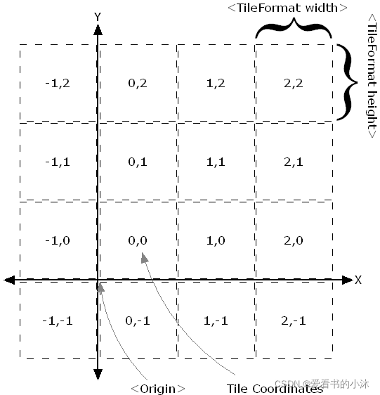
TMS是纯Restful;而WMTS可以有KVP、SOAP和Restful三种。
TMS瓦片是正方形的,而WMTS是矩形的(正方形是特殊的矩形)。
在纵轴方向上方向相反,TMS瓦片以左下角为原点,WMTS瓦片以左上角为原点。
1.9 切片地图web服务(WMTS)
https://www.ogc.org/standards/wmts

2、各种地图瓦片
腾讯、高德是GCJ02坐标系,百度是BD09坐标系,谷歌、必应是WGS84坐标系,天地图是CGCS2000坐标系,瓦片地图都是平面墨卡托投影。WGS84和CGCS2000坐标系,近似认为它们相等就可以。
| 地图商 | 瓦片编码 |
|---|---|
| 高德地图 | 谷歌XYZ |
| 谷歌地图 | 谷歌XYZ |
| OpenStreetMap | 谷歌XYZ |
| 腾讯地图 | TMS |
| Bing地图 | QuadTree |
| 百度地图 | 百度XYZ |
2.1 Google
谷歌地图瓦片层级是[0~21]。
// 谷歌矢量:
http://mt2.google.cn/vt/lyrs=m&scale=2&hl=zh-CN&gl=cn&x={x}&y={y}&z={z}
// 谷歌路网:
https://mt1.google.com/vt/lyrs=h&x={x}&y={y}&z={z}
// 谷歌影像:
http://www.google.cn/maps/vt?lyrs=s@189&gl=cn&x={x}&y={y}&z={z}
// 谷歌影像带注记:
https://mt1.google.com/vt/lyrs=y&x={x}&y={y}&z={z}
// 谷歌地形:
https://mt1.google.com/vt/lyrs=t&x={x}&y={y}&z={z}
// 谷歌地图矢量带地形渲染:
https://mt1.google.com/vt/lyrs=r&x={x}&y={y}&z={z}
// 其他
http://www.google.cn/maps/vt/pb=!1m4!1m3!1i'+str(zoom)+'!2i'+str(x)+'!3i'+str(y)+'!2m3!1e0!2sm!3i345013117!3m8!2szh-CN!3scn!5e1105!12m4!1e68!2m2!1sset!2sRoadmap!4e0
private static String Google_Satellite_Url = "http://mt0.google.cn/vt/lyrs=y&hl=zh-CN&hl=zh-CN&gl=CN&x={x}&y={y}&z={z}&s=Gali";
private static String Google_Image_Url = "http://mt0.google.cn/vt/lyrs=m&hl=zh-CN&hl=zh-CN&gl=CN&x={x}&y={y}&z={z}&s=Gali";
private static String Google_Terrain_Url = "http://mt0.google.cn/vt/lyrs=p&hl=zh-CN&hl=zh-CN&gl=CN&x={x}&y={y}&z={z}&s=Gali";
2.2 OpenStreetMap
OpenStreetMap(简称OSM)是一个网上地图协作计划,目标是创造一个内容自由且能让所有人编辑的世界地图。该平台的数据可以自由下载。OpenStreetMap(简称OSM)不仅可以免费在线使用,还可以免费下载原始数据,数据格式有.osm.pbf和shp。
// OSM瓦片网页地址:
https://tile.openstreetmap.org/{z}/{x}/{y}.png
https://c.tile.openstreetmap.org/{z}/{x}/{y}.png
https://tile-b.openstreetmap.fr/hot/{z}/{x}/{y}.png
// OSM经纬度网页地址:
https://www.openstreetmap.org/#map=18/39.99476/116.30986&layers=O
| Name | URL template | zoomlevels |
|---|---|---|
| OSM ‘standard’ style | http://[abc].tile.openstreetmap.org/zoom/x/y.png | 0-19 |
| OpenCycleMap | http://[abc].tile.thunderforest.com/cycle/zoom/x/y.png | 0-22 |
| Thunderforest Transport | http://[abc].tile.thunderforest.com/transport/zoom/x/y.png | 0-22 |
| MapQuest As of July 11, 2016, direct tile access has been discontinued. | http://otile[1234].mqcdn.com/tiles/1.0.0/osm/zoom/x/y.jpg (“otile1-s.mqcdn.com” etc. for https) | 0-18 |
| MapQuest Open Aerial, As of July 11, 2016, direct tile access has been discontinued. | http://otile[1234].mqcdn.com/tiles/1.0.0/sat/zoom/x/y.jpg | 0-11 globally, 12+ in the U.S. |
| Stamen Terrain | http://tile.stamen.com/terrain-background/zoom/x/y.jpg | 4-18, US-only (for now) |
2.3 ArcGIS
// 街道图:
https://map.geoq.cn/ArcGIS/rest/services/ChinaOnlineCommunity/MapServer/tile/{z}/{y}/{x}
// 灰色图:
https://map.geoq.cn/ArcGIS/rest/services/ChinaOnlineStreetGray/MapServer/tile/{z}/{y}/{x}
// 深蓝夜色:
https://map.geoq.cn/ArcGIS/rest/services/ChinaOnlineStreetPurplishBlue/MapServer/tile/{z}/{y}/{x}

// 其他
https://services.arcgisonline.com/arcgis/rest/services/World_Imagery/MapServer/tile/{z}/{y}/{x}
举例1(北大未名湖):
https://map.geoq.cn/ArcGIS/rest/services/ChinaOnlineCommunity/MapServer/tile/18/99247/215766
http://wprd02.is.autonavi.com/appmaptile?x=215766&y=99247&z=18&style=7


举例2(北大未名湖):
https://services.arcgisonline.com/arcgis/rest/services/World_Imagery/MapServer/tile/18/99247/215766
https://a.tile.openstreetmap.org/18/215766/99247.png


举例3(纽约旁的小岛):
https://services.arcgisonline.com/arcgis/rest/services/World_Imagery/MapServer/tile/18/98434/77343
https://a.tile.openstreetmap.org/18/77343/98434.png


2.4 高德地图
高德地图瓦片坐标与 Google Map、Open Street Map 相同。高德地图的墨卡托投影截取了纬度(约85.05oS, 约85.05oN)之间部分的地球,使得投影后的平面地图水平方向和垂直方向长度相等。将墨卡托投影地图的左上角作为瓦片坐标系起点,往左方向为X轴,X轴与北纬85.05o重合且方向向左;往下方向为Y轴,Y轴与东经180o(亦为西经180o)重合且方向向下。瓦片坐标最小等级为0级,此时平面地图是一个像素为256*256的瓦片。
高德地图的坐标是GCJ-02坐标(国内的所有地图都是,有的还进行了二次加偏),高德的瓦片分割方式和谷歌的一样,style=7是路线图,6的话是卫星图。
高德的z取值范围是[1,19]。不过卫星图实测只能取到18。
瓦片请求地址参数说明如下:
| 变量 | 说明 |
|---|---|
| 域名(wprd,wpst) | 据说wprd0前者是高德的新版地址,webst0后者是老版地址。 |
| lang | zh_cn设置中文,en设置英文 |
| size | 无作用 |
| style | 地图类型控制,6卫星(st),7简图(st rd),8详图(不透明rd,透明图st) |
| scl | 尺寸控制,1=256,2=512 |
| ltype | 只对地图要素进行控制 |
// 高德影像
https://webst01.is.autonavi.com/appmaptile?style=6&x={x}&y={y}&z={z}
// 高德路网
https://wprd01.is.autonavi.com/appmaptile?x={x}&y={y}&z={z}&lang=zh_cn&size=1&scl=2&style=8<ype=3
// 高德矢量
http://wprd04.is.autonavi.com/appmaptile?lang=zh_cn&size=1&style=7&x={x}&y={y}&z={z}
// 高德道路纯图
https://wprd01.is.autonavi.com/appmaptile?lang=zh_cn&size=1&style=7&x=215766&y=99247&z=18&scl=1<ype=2
// 高德道路简图
http://webrd01.is.autonavi.com/appmaptile?x=215766&y=99247&z=18&size=1&scale=1&style=7
// 高德道路详图
http://webrd01.is.autonavi.com/appmaptile?x=215766&y=99247&z=18&lang=zh_cn&size=1&scale=1&style=8
- 其他
url:"https://webst{s}.is.autonavi.com/appmaptile?x={x}&y={y}&z={z}&style=6", // 添加高德影像
subdomains:["01","02","03","04"] //多域名请求
private static String AMap_Satellite_Url = "http://webst02.is.autonavi.com/appmaptile?style=6&x={x}&y={y}&z={z}";
private static String AMap_Cover_Url = "http://webst02.is.autonavi.com/appmaptile?x={x}&y={y}&z={z}&lang=zh_cn&size=1&scale=1&style=8";
private static String AMap_Image_Url = "http://webrd03.is.autonavi.com/appmaptile?lang=zh_cn&size=1&scale=1&style=8&x={x}&y={y}&z={z}";

2.5 Bing地图
https://r1.tiles.ditu.live.com/tiles/r1321001.png?g=1001&mkt=zh-cn
http://dynamic.t2.tiles.ditu.live.com/comp/ch/{quadkey}?it=G,OS,L&mkt=en-us&cstl=w4c&ur=cn
2.6 百度地图
百度图片瓦片的层级是[3~18]。
http://online1.map.bdimg.com/onlinelabel/?qt=tile&x=49310&y=10242&z=18
2.7 搜狗地图
http://p2.go2map.com/seamless1/0/174/717/3/1/744_212.png
2.8 腾讯地图
https://rt1.map.gtimg.com/tile?z=3&x=7&y=5&styleid=1&version=117
2.9 天地图
http://lbs.tianditu.gov.cn/server/MapService.html
http://t0.tianditu.gov.cn/img_w/wmts?SERVICE=WMTS&REQUEST=GetTile&VERSION=1.0.0&LAYER=img&STYLE=default&TILEMATRIXSET=w&FORMAT=tiles&TILEMATRIX=18&TILEROW=99247&TILECOL=215766&tk=您的密钥
https://t0.tianditu.gov.cn/DataServer?T=cia_w&x=16&y=24&l=6&tk=您的密钥
3、代码实现
#***********************************************************************
# Purpose: python下载和拼接地图瓦片(高德和google地图)
# Author: 爱看书的小沐
# Date: 2022-03-04
# Languages: Python
# Platform: Python 3.9.7 win64
# ***********************************************************************
# -*-coding:utf-8 -*-
import os
import math
import urllib.request
import PIL.Image as Image
from PIL import ImageDraw, ImageFont
file_path='d:/maps'
# (1) 全球地图
zoom = 2
xmin = ymin = 0
xmax = ymax = pow(2, zoom)
# (2) 局部地图
# zoom = 18 #19
# xmin = 215768
# ymin = 99253
# xmax = xmin + 4
# ymax = ymin + 4
#################################################################
# 图片拼接
#################################################################
mylog = open(file_path + '/err.log', mode = 'a',encoding='utf-8')
for x in range(xmin, xmax):
for y in range(ymin, ymax):
#Google影像瓦片
# img_url = 'http://mt2.google.cn/vt/lyrs=y&hl=zh-CN&gl=CN&src=app&x='+str(x)+'&y='+str(y)+'&z='+str(zoom)+'&s=G'
#高德瓦片,wprd03想必是和谷歌一样,有多个服务器提供服务。测试下来可以取到01 到 04。
img_url = 'https://wprd01.is.autonavi.com/appmaptile?x={x}&y={y}&z={z}&style=6'.format(x=x, y=y, z=zoom)
#img_url = 'https://wprd01.is.autonavi.com/appmaptile?x={x}&y={y}&z={z}&lang=zh_cn&size=1&scl=1&style=7<ype=0'.format(x=x, y=y, z=zoom)
print(img_url)
file_name=str(y)+'.png'
path = file_path + "/" + str(zoom) + "/" + str(x)
if not os.path.exists(path):
os.makedirs(path)
fname = path + '/'+ file_name
print(fname)
try:
urllib.request.urlretrieve(img_url,filename=fname)
except IOError as e:
print("IOError:"+str(x)+','+str(y))
print(img_url, file=mylog)
except Exception as e:
print("Exception:"+str(x)+','+str(y))
print(img_url, file=mylog)
mylog.close()
#################################################################
# 图片拼接
#################################################################
mw = 256
toImage = Image.new('RGB', (256*(xmax-xmin), 256*(ymax-ymin)) )
def num2deg(xtile, ytile, zoom):
n = 2.0 ** zoom
lon_deg = xtile / n * 360.0 - 180.0
lat_rad = math.atan(math.sinh(math.pi * (1 - 2 * ytile / n)))
lat_deg = math.degrees(lat_rad)
return (lat_deg, lon_deg)
for x in range(xmin, xmax):
for y in range(ymin, ymax):
fname =file_path + '/' + str(zoom) +'/' + str(x)+'/'+str(y)+'.png'
fromImage = Image.open(fname)
draw = ImageDraw.Draw(fromImage)
# 添加每个瓦片的文字信息
fontSize = 18
setFont = ImageFont.truetype('C:/windows/fonts/arial.ttf', fontSize)
fillColor = "#ffff00"
pos = num2deg(x, y, zoom)
text = 'Tile: ' + str(x)+ "," + str(y)+ "," + str(zoom)
text2 = 'Lat: %.6f'%pos[0]
text3 = 'Lon: %.6f'%pos[1]
draw.text((1,1), text,font=setFont,fill=fillColor)
draw.text((1,1+fontSize), text2,font=setFont,fill=fillColor)
draw.text((1,1+2*fontSize), text3,font=setFont,fill=fillColor)
# 添加每个瓦片的边框线条
draw.rectangle([0, 0, mw-1, mw-1], fill=None, outline='red', width=1)
# 将每个瓦片的小图绘制到大图里面。
toImage.paste(fromImage, ((x-xmin) * mw, (y-ymin) * mw))
toImage.save(file_path + '/' + str(zoom) +'/preview.png' )
toImage.close()
print("ok")
4、运行结果
4.1 输出全球图
// 地图瓦片坐标相关参数设置
zoom = 5
xmin = ymin = 0
xmax = ymax = pow(2, zoom)


左上角第一行文字:列序号x,行序号y,级别zoom
左上角第二行文字:纬度
左上角第三行文字:经度
-
第1级别:
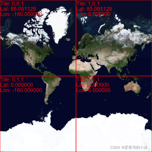
-
第2级别:

-
第3级别:

4.2 输出局部图
随机取一个位置的经纬度,计算它的瓦片坐标,同时构造瓦片网页地址。
#***********************************************************************
# Purpose: python根据经纬度,计算对应的瓦片坐标
# Author: 爱看书的小沐
# Date: 2022-03-05
# Languages: Python
# Platform: Python 3.9.7 win64
# ***********************************************************************
# -*-coding:utf-8 -*-
import math
def deg2num(lat_deg, lon_deg, zoom):
lat_rad = math.radians(lat_deg)
n = 2.0 ** zoom
xtile = int((lon_deg + 180.0) / 360.0 * n)
ytile = int((1.0 - math.asinh(math.tan(lat_rad)) / math.pi) / 2.0 * n)
return (xtile, ytile)
def deg2url(lat_deg, lon_deg, zoom):
lat_rad = math.radians(lat_deg)
n = 2.0 ** zoom
xtile = int((lon_deg + 180.0) / 360.0 * n)
ytile = int((1.0 - math.asinh(math.tan(lat_rad)) / math.pi) / 2.0 * n)
return 'https://wprd01.is.autonavi.com/appmaptile?x={x}&y={y}&z={z}&lang=zh_cn&size=1&scl=1&style=7<ype=0'.format(x=xtile, y=ytile, z=zoom)
def deg2numrange(lat_deg1, lon_deg1, lat_deg2, lon_deg2, zoom):
tile1 = deg2num(lat_deg1, lon_deg1, zoom)
tile2 = deg2num(lat_deg2, lon_deg2, zoom)
tile1new = min(tile1[0], tile2[0]), min(tile1[1], tile2[1])
tile2new = max(tile1[0], tile2[0]), max(tile1[1], tile2[1])
return [tile1new[0], tile1new[1], tile2new[0] - tile1new[0], tile2new[1] - tile1new[1]]
# 输出瓦片坐标
print(deg2num(39.98836718933446, 116.31269474242018, 18))
# 输出瓦片网址
print(deg2url(39.90854390955025, 116.43579204294966, 18))
# 输出两个经纬度之间的瓦片坐标
print(deg2numrange(39.98860557371063, 116.31227095339582, 39.98675601794477, 116.31610114786909, 18))
设置局部地图(以北京大学的足球体育场为例)的瓦片坐标参数如下,进行批量操作。
// 地图瓦片坐标相关参数设置
zoom = 18
xmin = 215768
ymin = 99253
xmax = xmin + 4
ymax = ymin + 4
// 高德卫星影像图
https://wprd01.is.autonavi.com/appmaptile?x={x}&y={y}&z={z}&style=6

// 高德交通路网图
https://wprd01.is.autonavi.com/appmaptile?x={x}&y={y}&z={z}&lang=zh_cn&size=1&scl=1&style=7<ype=0

后记
如果你觉得该方法或代码有一点点用处,可以给作者点个赞、赏杯咖啡;╮( ̄▽ ̄)╭
如果你感觉方法或代码不咋地//(ㄒoㄒ)//,就在评论处留言,作者继续改进。o_O???
谢谢各位童鞋们啦( ′ ▽′ )ノ ( ′ ▽′)っ!!!