多传感器融合定位 (单天线gps+ndt匹配)初始化重定位
参考博客:多传感器融合定位 第四章 点云地图构建及基于点云地图定位
最近工作比较繁忙,所以课程第九章预积分开始的内容,并没有跟上,在之后的日子里会慢慢跟上~
最近项目使用自己的数据集跑定位,目前使用的设备为 双天线RTK + 九轴IMU + 16线Lidar
存在问题:
1.九轴的IMU磁场计受到较大的影响,导致姿态不准确,并且客户每次使用都需要校准,不太方便;
2.为了节约成本有时会使用单天线gps和六轴IMU,只能得到初始大概位置和基于上电时刻的相对姿态,不能得到导航系下的姿态;
解决:
鉴于上述的实际问题,考虑采用 (gps 初始化position、PointCloud_Registration初始化的方法)进行重定位初始化
1.代码框架
整体代码框架为基于先验地图的定位,在 多传感器融合定位 第七章 基于滤波的融合方法的代码框架基础上进行开发。
初始化位姿(POSE)包括两部分 : 初始化位置(POSI) 初始化姿态(ORI)
1.1初始化位置(POSI):
使用GPS获得当前车体所在的经纬高,并转换为导航系下的导航系(XYZ)坐标,并获取当前所在位置的局部地图
1.2初始化姿态(ORI):
当前点云地图 和 上一步获取的局部地图 进行点云配准,获取初始姿态角。
1.3点云配准算法:
NDT、ICP、Loam 、 ScanContext 均可, 本次使用的配准算法为pcl_ndt
2.算法实现流程
当前的点云 m_current、局部地图的点云 m_local、ndt匹配的先验位姿 predict_pose、ndt匹配后的得分 fitness_score
#step 1     获取当前的点云数据和gnss数据
#step 2    通过gnss返回的载体当前所在地图上的坐标,分割出局部地图的点云 m_local
#step 3    初始化ndt匹配的先验位姿 predict_pose 的 旋转部分 为单位阵、位置部分为step2得到的 posi
#step 3    将360度分成72份,每旋转5度为1份,predict_pose 每次绕Z轴旋转5度,输入到pcl_ndt中,进行 m_current  m_local 点云匹配,  并输出匹配后的得分 score
#step 4     选出得分最低的配准结果对应的旋转矩阵temp_init_rotation,作为定位初始姿态
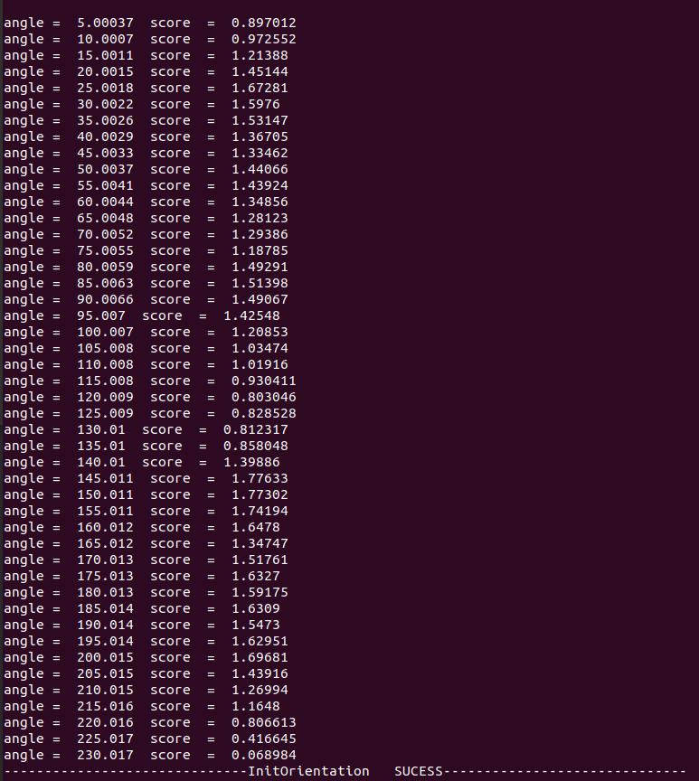
trick: 进行72次(每5度)一次的旋转匹配中,发现正确的姿态和错误的姿态,在score上有较大的差异,如下表所示,为输入 predict_pose 旋转 5-360 ndt 匹配分数,正确的匹配角度为 60-65 之间,score分数对比其他错误姿态明显很小,为了加速初始化,可通过设置score阈值的方法进行加速初始化。
| angle = 5.00037 score = 8.01031 angle = 10.0007 score = 7.6049 angle = 15.0011 score = 6.99564 angle = 20.0015 score = 5.50515 angle = 25.0018 score = 5.58489 angle = 30.0022 score = 5.34696 angle = 35.0026 score = 4.43976 angle = 40.0029 score = 3.23621 angle = 45.0033 score = 2.3229 angle = 50.0037 score = 1.71253 angle = 55.0041 score = 0.800658 angle = 60.0044 score = 0.0609917 angle = 65.0048 score = 0.0612495 angle = 70.0052 score = 0.805328 angle = 75.0055 score = 1.18486 angle = 80.0059 score = 1.70853 angle = 85.0063 score = 2.08244 angle = 90.0066 score = 2.84847 angle = 95.007 score = 4.08729 angle = 100.007 score = 5.58512 angle = 105.008 score = 8.91464 angle = 110.008 score = 9.46592 angle = 115.008 score = 8.968 angle = 120.009 score = 10.8153 | angle = 125.009 score = 12.5608 angle = 130.01 score = 11.598 angle = 135.01 score = 9.47127 angle = 140.01 score = 9.09879 angle = 145.011 score = 9.46195 angle = 150.011 score = 8.57565 angle = 155.011 score = 8.03287 angle = 160.012 score = 7.2493 angle = 165.012 score = 7.13777 angle = 170.013 score = 5.51928 angle = 175.013 score = 4.88985 angle = 180.013 score = 3.738 angle = 185.014 score = 3.34093 angle = 190.014 score = 3.30719 angle = 195.014 score = 3.40997 angle = 200.015 score = 3.53268 angle = 205.015 score = 3.8749 angle = 210.015 score = 4.32289 angle = 215.016 score = 4.51662 angle = 220.016 score = 4.2599 angle = 225.017 score = 4.02596 angle = 230.017 score = 3.53537 angle = 235.017 score = 3.18032 angle = 240.018 score = 3.20526 | angle = 245.018 score = 2.85211 angle = 250.018 score = 2.21396 angle = 255.019 score = 1.99666 angle = 260.019 score = 1.93678 angle = 265.02 score = 1.92775 angle = 270.02 score = 2.59312 angle = 275.02 score = 3.13421 angle = 280.021 score = 3.19898 angle = 285.021 score = 3.44148 angle = 290.021 score = 4.13718 angle = 295.022 score = 5.13398 angle = 300.022 score = 5.79304 angle = 305.022 score = 5.242 angle = 310.023 score = 5.00261 angle = 315.023 score = 3.70704 angle = 320.024 score = 3.63942 angle = 325.024 score = 3.96029 angle = 330.024 score = 4.7522 angle = 335.025 score = 5.44406 angle = 340.025 score = 5.60252 angle = 345.025 score = 5.92031 angle = 350.026 score = 7.90565 angle = 355.026 score = 7.74071 angle = 360.027 score = 8.39916 |
|---|
3.核心代码
3.1 根据gps分割出的局部地图进行ndt配准,根据配准score 获取初始化姿态
FILE : kitti_filtering.cpp
bool KITTIFiltering::InitOri(Eigen::Matrix4f &init_pose,   CloudData &cloud_data ,  Eigen::Matrix3f &init_ori ){        //  use gnss and though ndt get  init_ori
      init_pose.block<3,3>(0,0)  =   Eigen::Matrix3f::Identity();       //   初始化旋转部分为单位阵
      Eigen::Matrix4f  predict_pose =  init_pose;

      ResetLocalMap(predict_pose(0, 3), predict_pose(1, 3), predict_pose(2, 3));         //   根据gnss 的posi加载局部地图
       // remove invalid measurements:
      std::vector<int> indices;
      pcl::removeNaNFromPointCloud(*cloud_data.cloud_ptr, *cloud_data.cloud_ptr,
                              indices);
      // downsample:
      CloudData::CLOUD_PTR filtered_cloud_ptr(new CloudData::CLOUD());
      current_scan_filter_ptr_->Filter(cloud_data.cloud_ptr, filtered_cloud_ptr);

      Eigen::Matrix4f  temp_init_pose  =  Eigen::Matrix4f::Identity();     //  ndt 匹配得到的变换矩阵
       int iter_rate  =72;
       for(int i = 1; i <  iter_rate + 1;  i++){     //  分成72份
             double  angle =   2*M_PI /  72 * i;
             predict_pose  = init_pose;
             Eigen::AngleAxisf rotation_vector(angle,  Eigen::Vector3f(0,0,1))  ;   // 绕z轴旋转
             Eigen::Matrix3f    rotation_ =  rotation_vector.matrix();
            predict_pose.block<3,3>(0,0)  =  rotation_ *  predict_pose.block<3,3>(0,0);

          // matching:
            CloudData::CLOUD_PTR result_cloud_ptr(new CloudData::CLOUD());
            registration_ptr_->ScanMatch(filtered_cloud_ptr, predict_pose,
                                        result_cloud_ptr, temp_init_pose);

            float  score =   registration_ptr_->GetFitnessScore();         //  获取匹配分数
            std::cout  <<  "angle =  "<<  (angle * 57.3 ) << "  score  =  "   <<   score  <<std::endl;
             if(score < 0.1){break;}   // 得分小于 0.1 跳出循环
       }
      predict_pose.block<3,3>(0,0)  =  temp_init_pose.block<3,3>(0,0);       // 获取配准质量高的姿态
     // matching:
      CloudData::CLOUD_PTR result_cloud_ptr(new CloudData::CLOUD());
      registration_ptr_->ScanMatch(filtered_cloud_ptr, predict_pose,
                                  result_cloud_ptr, temp_init_pose);

      init_ori.block<3,3>(0,0)  =  temp_init_pose.block<3,3>(0,0);     //  更新init  pose的航向
}
3.2 获取第一帧gnss 和 point_cloud 数据,调用 init_ori 初始化
FILE: kitti_filtering_flow.cpp
这里参考 KITTIFilteringFlow::InitCalibration() 这部分的写法,接受到第一帧数据后,进行阻塞匹配,匹配完成后,清空数据buff,舍弃匹配过程中所有数据,更新数据进行下一步的定位。
bool  KITTIFilteringFlow::InitOrientation(){
     static bool InitOrientation_received = false;
     if(!InitOrientation_received){
          ReadData();      //  订阅传感器的话题,并将数据存储到buff 中
     }
     if ( (!InitOrientation_received) &&( HasData()) ) {
      //  use  pcl_ndt   registration  to  init
      current_gnss_data_    =   gnss_data_buff_.front();        //   提取第一帧gnss数据,做位置初始化,提取local_map
      current_cloud_data_  =   cloud_data_buff_.front();      //  提取第一帧点云数据

      filtering_ptr_->InitOri(current_gnss_data_.pose,   current_cloud_data_, init_ori_);
      // std::cout << "init_ori_  "  <<  "\n"<< init_ori_  << std::endl;
      imu_raw_data_buff_.clear();     //    清空缓存数据
      cloud_data_buff_.clear();
      imu_synced_data_buff_.clear();
      pos_vel_data_buff_.clear();
      gnss_data_buff_.clear();
      InitOrientation_received  = true;
     std::cout << "------------------------------InitOrientation   SUCESS------------------------------"  << std::endl;
     }
    return  InitOrientation_received;
}
3.3 更新 current_gnss_data_.pose 为配准后的pose
FILE: kitti_filtering_flow.cpp KITTIFilteringFlow::InitLocalization(void)
current_gnss_data_.pose.block<3,3>(0,0) = init_ori_.block<3,3>(0,0); // 修正姿态
3.4 调用 InitOrientation
FILE: kitti_filtering_flow.cpp KITTIFilteringFlow::Run()
  if(!InitOrientation()){
    return  false;
  }
4. 实验结果
4.1 使用
roslaunch lidar_localization kitti_localization.launch
rosbag  play  kitti_lidar_only_2011_10_03_drive_0027_synced.bag
4.2 结果
在不同的地方进行播放地图,大致可以完成初始化
原点播放数据集
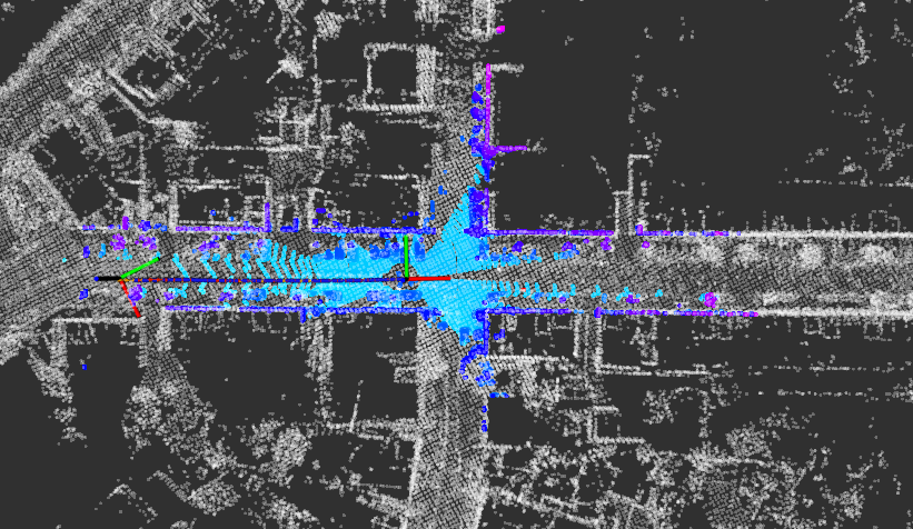
95s播放数据集合
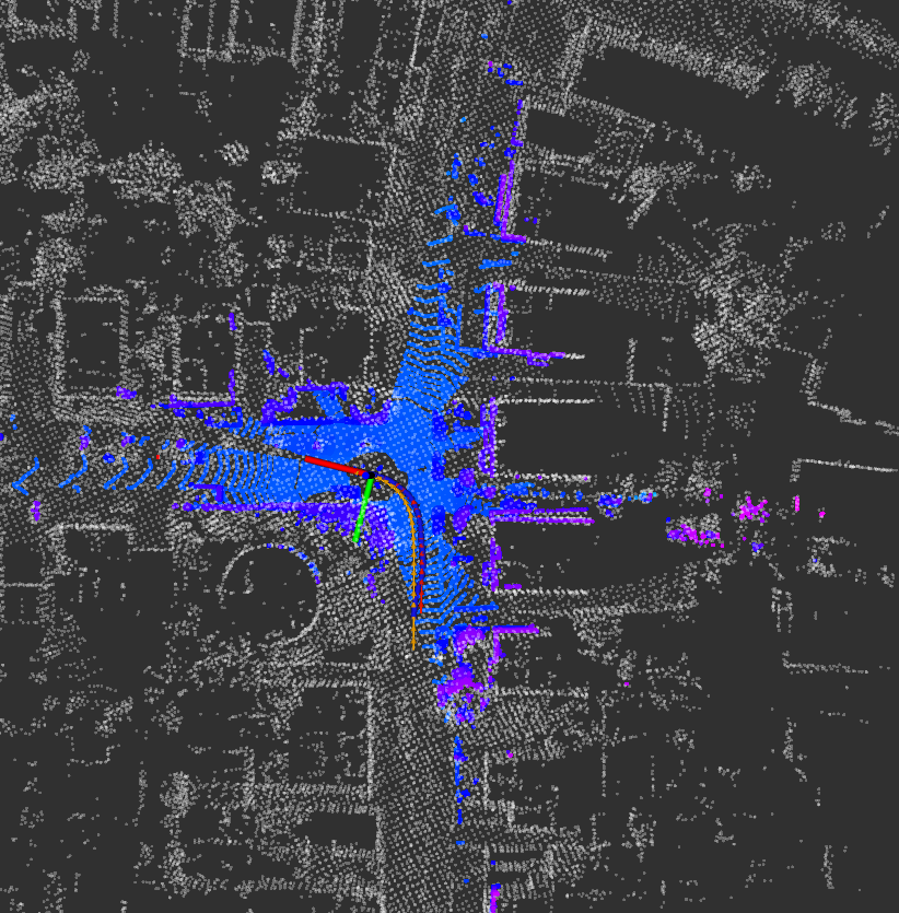
200s播放数据集合
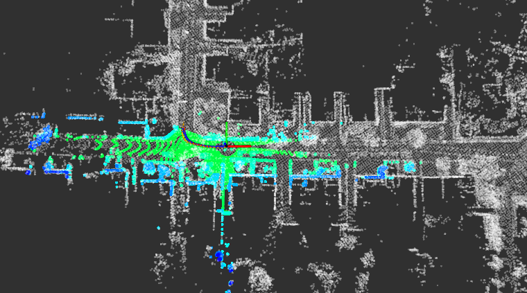
300s播放数据集合
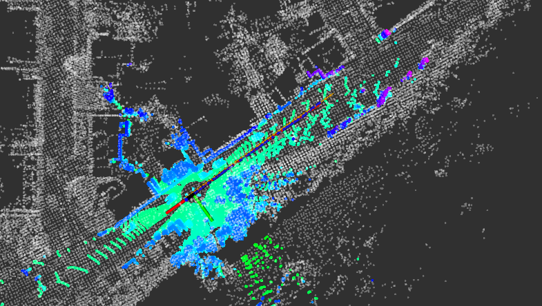
5.存在问题
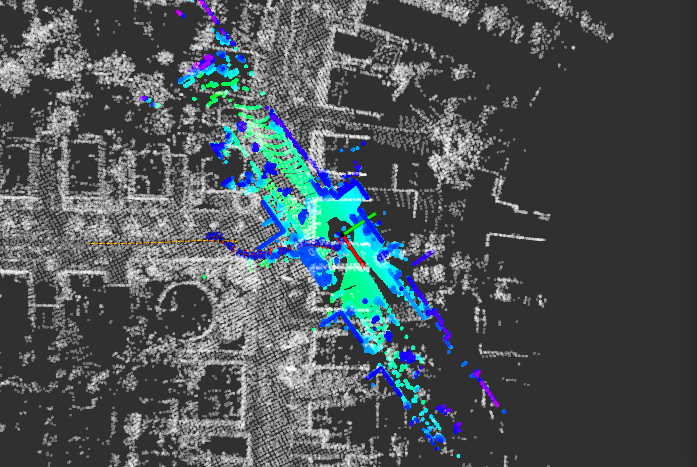
在播放100s的数据时发现,初始化结束后,定位跑飞了,原因在于播放100s数据集所在地方刚好在转角处(姿态改变方向的位置),并且角度在230度附近,需要较长的初始化匹配时间,初始化成功后,当前载体的姿态已经换向和原来方向差异大
后续优化方向:
1.优化遍历角度的方法,可采用二叉树的思路,加快遍历速度,进而提高初始化姿态的效率
2.尝试loam、scancontext等匹配方法,加快匹配效率。
? edited by kaho 11.21